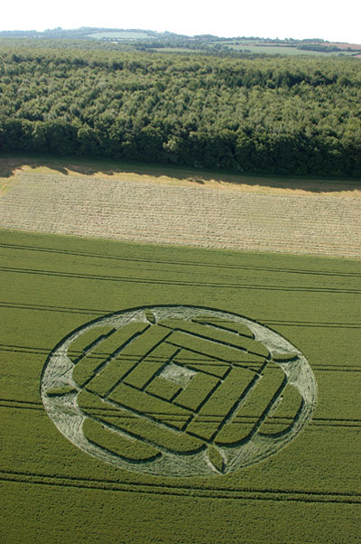
Photo by Steve Alexander, Crop Circle Archives (Crop Circle Connector)
Boreham Down, wiltshire 22 June 2005, wheat, 27 photos
Date 22 June 2005
Place Boreham Down, near Lockeridge
County or region wiltshire
Country England
Crop Wheat
GPS 51.39602, -1.80375
OS grid reference SU 137 663
Nearest ancient site East Kennett Long Barrow, 2.1 km
Reference codes LP-CCDB uk2005at Photos27
Photo by Steve Alexander, Crop Circle Archives (Crop Circle Connector)
Crop Circle Archives (Crop Circle Connector)
Crop Circle Archives (Crop Circle Connector)
Crop Circle Archives (Crop Circle Connector)
Crop Circle Archives (Crop Circle Connector)
Photo by Stuart Dike, Crop Circle Archives (Crop Circle Connector)
Photo by Stuart Dike, Crop Circle Archives (Crop Circle Connector)
Photo by Stuart Dike, Crop Circle Archives (Crop Circle Connector)
Photo by Stuart Dike, Crop Circle Archives (Crop Circle Connector)
Photo by Stuart Dike, Crop Circle Archives (Crop Circle Connector)
Photo by Bertold Zugelder, Crop Circle Archives (Crop Circle Connector)
Photo by Lucy Pringle, Crop Circle Archives (Crop Circle Connector)
Photo by John Dove, Crop Circle Archives (Crop Circle Connector)
Photo by John Dove, Crop Circle Archives (Crop Circle Connector)
Photo by Michael Murray, Crop Circle Archives (Crop Circle Connector)
Photo by Michael Murray, Crop Circle Archives (Crop Circle Connector)
Photo by Michael Murray, Crop Circle Archives (Crop Circle Connector)
Photo by Michael Murray, Crop Circle Archives (Crop Circle Connector)
Photo by Michael Murray, Crop Circle Archives (Crop Circle Connector)
Photo by Michael Murray, Crop Circle Archives (Crop Circle Connector)
Photo by Michael Murray, Crop Circle Archives (Crop Circle Connector)
Photo by Michael Murray, Crop Circle Archives (Crop Circle Connector)
Photo by Michael Murray, Crop Circle Archives (Crop Circle Connector)
Photo by Michael Murray, Crop Circle Archives (Crop Circle Connector)
Temporary Temples
Temporary Temples
Photo by Lucy Pringle, Lucy Pringle Crop Circle Photography Photos load from the archives that published them and remain the copyright of their photographers. Crop circle images and reports courtesy The Crop Circle Connector (cropcircleconnector.com). All sources and credits .
Reports
Crop Circle at Boreham Down, nr Lockeridge, wiltshire. Reported 22nd June 2005 Boreham Down, nr Lockeridge, Wiltshire. Reported 22nd June. Map Ref: SU137663 Updated Thursday 8th December 2005 Image Steve Alexander Copyright 2005 As you can see someone has walked across the Field to the crop circle. please keep to…
A complex design of ever-enlarging rectangles spiralling out from the centre