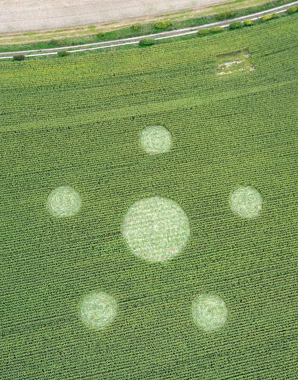
Photo by Olivier Morel, Crop Circle Archives (Crop Circle Connector)
Hill Barnl, Wiltshire 26 September 2010, maize, 25 photos
Date 26 September 2010
Place Hill Barnl, near Lockeridge
County or region Wiltshire
Country England
Crop Maize
GPS 51.40322, -1.80372
OS grid reference SU 137 671
Nearest ancient site East Kennett Long Barrow, 2.1 km Photos25
Photo by Olivier Morel, Crop Circle Archives (Crop Circle Connector)
Photo by Olivier Morel, Crop Circle Archives (Crop Circle Connector)
Photo by Olivier Morel, Crop Circle Archives (Crop Circle Connector)
Photo by Greg Toogood, Crop Circle Archives (Crop Circle Connector)
Photo by Matthew Williams, Crop Circle Archives (Crop Circle Connector)
Photo by Busty Taylor, Crop Circle Archives (Crop Circle Connector)
Photo by Busty Taylor, Crop Circle Archives (Crop Circle Connector)
Photo by Olivier Morel, Crop Circle Archives (Crop Circle Connector)
Photo by Taiwan, Crop Circle Archives (Crop Circle Connector)
Crop Circle Archives (Crop Circle Connector)
Crop Circle Archives (Crop Circle Connector)
Crop Circle Archives (Crop Circle Connector)
Crop Circle Archives (Crop Circle Connector)
Photo by Olivier Morel, Crop Circle Archives (Crop Circle Connector)
Photo by Olivier Morel, Crop Circle Archives (Crop Circle Connector)
Photo by Olivier Morel, Crop Circle Archives (Crop Circle Connector)
Photo by Olivier Morel, Crop Circle Archives (Crop Circle Connector)
Photo by Olivier Morel, Crop Circle Archives (Crop Circle Connector)
Photo by Olivier Morel, Crop Circle Archives (Crop Circle Connector)
Photo by Olivier Morel, Crop Circle Archives (Crop Circle Connector)
Photo by Olivier Morel, Crop Circle Archives (Crop Circle Connector)
Photo by Olivier Morel, Crop Circle Archives (Crop Circle Connector)
Photo by Olivier Morel, Crop Circle Archives (Crop Circle Connector)
Photo by George Coleman, Crop Circle Archives (Crop Circle Connector)
Photo by George Coleman, Crop Circle Archives (Crop Circle Connector) Photos load from the archives that published them and remain the copyright of their photographers. Crop circle images and reports courtesy The Crop Circle Connector (cropcircleconnector.com). All sources and credits .
Reports
Crop Circle at Hill Barnl, nr Lockeridge, Wiltshire. Reported 26th September 2010. Hill Barn, nr Lockeridge, Wiltshire. Reported 26th September. Map Ref: SU137671 Updated Monday 21st November 2016 AERIAL SHOTS GROUND SHOTS DIAGRAMS FIELD REPORTS COMMENTS ARTICLES 18/10/10 04/10/10 00/00/10 00/00/10 21/11/16…