Crop Circle Archives (Crop Circle Connector)
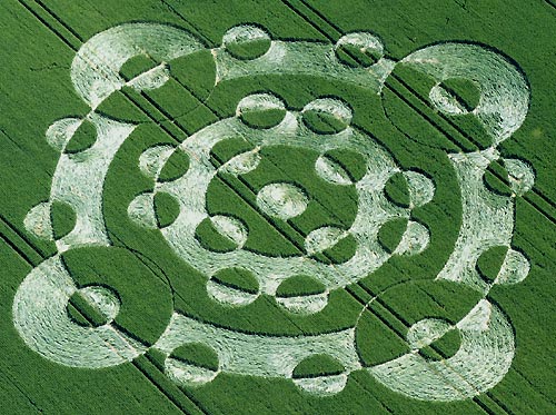
Lurkley Hill, Wiltshire 22 June 2005, wheat, 23 photos
Date 22 June 2005
Place Lurkley Hill, near Lockeridge
County or region Wiltshire
Country England
Crop Wheat
GPS 51.39337, -1.83107
OS grid reference SU 118 660
Nearest ancient site East Kennett Long Barrow, 0.6 km
Reference codes LP-CCDB uk2005au Photos23
Crop Circle Archives (Crop Circle Connector)
Crop Circle Archives (Crop Circle Connector)
Crop Circle Archives (Crop Circle Connector)
Crop Circle Archives (Crop Circle Connector)
Photo by Steve Alexander, Crop Circle Archives (Crop Circle Connector)
Photo by Nick Nicholson, Crop Circle Archives (Crop Circle Connector)
Photo by Nick Nicholson, Crop Circle Archives (Crop Circle Connector)
Photo by Nick Nicholson, Crop Circle Archives (Crop Circle Connector)
Photo by Bertold Zugelder, Crop Circle Archives (Crop Circle Connector)
Photo by Bertold Zugelder, Crop Circle Archives (Crop Circle Connector)
Photo by Bertold Zugelder, Crop Circle Archives (Crop Circle Connector)
Photo by Bertold Zugelder, Crop Circle Archives (Crop Circle Connector)
Photo by Bertold Zugelder, Crop Circle Archives (Crop Circle Connector)
Photo by Bertold Zugelder, Crop Circle Archives (Crop Circle Connector)
Photo by Bertold Zugelder, Crop Circle Archives (Crop Circle Connector)
Photo by Lucy Pringle, Crop Circle Archives (Crop Circle Connector)
Photo by John Dove, Crop Circle Archives (Crop Circle Connector)
Photo by John Dove, Crop Circle Archives (Crop Circle Connector)
Photo by John Dove, Crop Circle Archives (Crop Circle Connector)
Photo by Nick Nicholson, Crop Circle Archives (Crop Circle Connector)
Photo by Nick Nicholson, Crop Circle Archives (Crop Circle Connector)
Photo by Lucy Pringle, Crop Circle Archives (Crop Circle Connector)
Photo by Lucy Pringle, Lucy Pringle Crop Circle Photography Photos load from the archives that published them and remain the copyright of their photographers. Crop circle images and reports courtesy The Crop Circle Connector (cropcircleconnector.com). All sources and credits .
Reports
Crop Circle at Lurkley Hill. nr Lockeridge, Wiltshire. Reported 22nd June 2005 Lurkley Hill. nr Lockeridge, Wiltshire. Reported 22nd June. Map Ref: SU118660 Updated Tuesday 26th July 2005 Images CCC Copyright 2005 Image Steve Alexander Copyright 2005 Reconstruction of the 2005 Lurkeley Hill formation By Zef Damen…
An elaborate design of overlapping circles, giving a kind of positive/negative effect