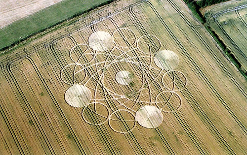
Photo by Bertold Zugelder, Crop Circle Archives (Crop Circle Connector)
Garsington, Oxfordshire 15 July 2005, wheat, 30 photos
Date 15 July 2005
Place Garsington
County or region Oxfordshire
Country England
Crop Wheat
GPS 51.70967, -1.15836
OS grid reference SP 582 015
Nearest ancient site Uffington White Horse, 31.8 km
Reference codes LP-CCDB uk2005bk Photos30
Photo by Bertold Zugelder, Crop Circle Archives (Crop Circle Connector)
Photo by Bertold Zugelder, Crop Circle Archives (Crop Circle Connector)
Photo by Bertold Zugelder, Crop Circle Archives (Crop Circle Connector)
Photo by Andrew King, Crop Circle Archives (Crop Circle Connector)
Photo by Andrew King, Crop Circle Archives (Crop Circle Connector)
Photo by Andrew King, Crop Circle Archives (Crop Circle Connector)
Photo by Andrew King, Crop Circle Archives (Crop Circle Connector)
Photo by Andrew King, Crop Circle Archives (Crop Circle Connector)
Photo by Axel Kayser, Crop Circle Archives (Crop Circle Connector)
Photo by Ellis C Taylor, Crop Circle Archives (Crop Circle Connector)
Photo by Russell Stannard, Crop Circle Archives (Crop Circle Connector)
Photo by Russell Stannard, Crop Circle Archives (Crop Circle Connector)
Photo by Russell Stannard, Crop Circle Archives (Crop Circle Connector)
Photo by Andrew King, Crop Circle Archives (Crop Circle Connector)
Photo by Andrew King, Crop Circle Archives (Crop Circle Connector)
Photo by Andrew King, Crop Circle Archives (Crop Circle Connector)
Photo by Andrew King, Crop Circle Archives (Crop Circle Connector)
Photo by Andrew King, Crop Circle Archives (Crop Circle Connector)
Photo by and the rest of them were taken by Axel Kayser, Crop Circle Archives (Crop Circle Connector)
Photo by and the rest of them were taken by Axel Kayser, Crop Circle Archives (Crop Circle Connector)
Photo by and the rest of them were taken by Axel Kayser, Crop Circle Archives (Crop Circle Connector)
Photo by and the rest of them were taken by Axel Kayser, Crop Circle Archives (Crop Circle Connector)
Photo by and the rest of them were taken by Axel Kayser, Crop Circle Archives (Crop Circle Connector)
Photo by and the rest of them were taken by Axel Kayser, Crop Circle Archives (Crop Circle Connector)
Photo by and the rest of them were taken by Axel Kayser, Crop Circle Archives (Crop Circle Connector)
Photo by and the rest of them were taken by Axel Kayser, Crop Circle Archives (Crop Circle Connector)
Photo by and the rest of them were taken by Axel Kayser, Crop Circle Archives (Crop Circle Connector)
Photo by and the rest of them were taken by Axel Kayser, Crop Circle Archives (Crop Circle Connector)
Photo by and the rest of them were taken by Axel Kayser, Crop Circle Archives (Crop Circle Connector)
Photo by Lucy Pringle, Lucy Pringle Crop Circle Photography Photos load from the archives that published them and remain the copyright of their photographers. Crop circle images and reports courtesy The Crop Circle Connector (cropcircleconnector.com). All sources and credits .
Reports
Crop Circle at Garsington, Oxfordshire. Reported 15th July 2005 Garsington, Oxfordshire. Reported 15th July. Map Ref: SP582015 Updated Friday 29th July 2005 Diagram Bertold Zugelder Copyright 2004 www.cropcircle-archive.com Image Andrew King Copyright 2005 Garsington, Oxfordshire. Reported 15th July. HI, I have…
Crop Circle at Garsington (2), Oxfordshire. Reported 15th July 2005 Garsington (2), Oxfordshire. Reported 15th July. Map Ref: SP587026 Updated Thursday 1st September 2005 Here are 4 key images of the altered Garsington 2 formation. Latest photos taken on Monday 8 August. Images Andrew King Copyright 2005 Image Axel…
A complex but rather untidy looking arrangement of circles around a central circle