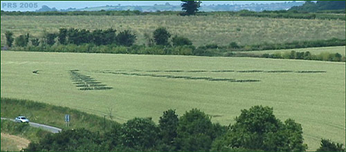
Photo by Peter Sorensen, Crop Circle Archives (Crop Circle Connector)
- Date
- 12 July 2005
- Place
- Clays End, near Twerton, North
- County or region
- Somerset
- Country
- England
- Crop
- Wheat
- GPS
- 51.38030, -2.41585
- OS grid reference
- ST 7115 6466
- Nearest ancient site
- Stanton Drew, 11.3 km
Photos9
Photos load from the archives that published them and remain the copyright of their photographers. Crop circle images and reports courtesy The Crop Circle Connector (cropcircleconnector.com). All sources and credits.
Reports
Crop Circle Archives (Crop Circle Connector)
Crop Circle at Clays End, Nr Twerton, North Somerset. Reported 12th July 2005 Clays End, Nr Twerton, North Somerset. Reported 10th July. Map Ref: ST71156466 Updated Friday 15th July 2005 All Image Peter Sorensen Copyright 2005 On my way to visit a new friend near Glastonbury, as we drove over a hill south of Bath…
Photos by Peter Sorensen, Colin Hudson. Read the full report at Crop Circle Archives.