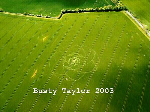
Photo by Busty Taylor, Crop Circle Archives (Crop Circle Connector)
- Date
- 21 May 2003
- Place
- West Overton, near Avebury
- County or region
- Wiltshire
- Country
- England
- Crop
- Barley
- GPS
- 51.40684, -1.82240
- OS grid reference
- SU 124 675
- Nearest ancient site
- The Sanctuary, 0.8 km
- Reference codes
- LP-CCDB uk2003ah
Photos7
Photos load from the archives that published them and remain the copyright of their photographers. Crop circle images and reports courtesy The Crop Circle Connector (cropcircleconnector.com). All sources and credits.
Reports
Crop Circle Archives (Crop Circle Connector)
Crop circle at West Overton, nr Avebury, Wiltshire. Reported 21st May. Reported 26th April 2003. West Overton, nr Avebury, Wiltshire. Reported 21st May. Map Ref: GPS SU124675 (appox) Updated Sunday 25th May 2003 Image Busty Taylor Copyright 2003 The Crop Circle Connector would like to thank Busty for the image.…
Photos by Busty Taylor, Dereka Dodson, Bertold Zugelder. Read the full report at Crop Circle Archives.
Lucy Pringle Crop Circle Photography
A large ring containing a six fold, recursive petal design within it. Telegraph pole within the formation A large ring containing a six fold, recursive petal design within it. Telegraph pole within the formation
Photos by Lucy Pringle. Read the full report at Lucy Pringle.