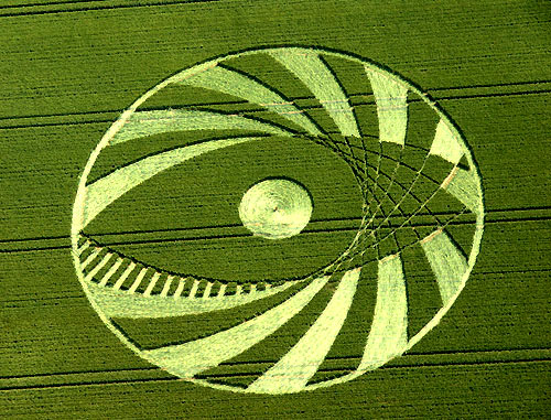
Photo by Steve Alexander, Crop Circle Archives (Crop Circle Connector)
Silbury Hill (2), Wiltshire 9 July 2005, wheat, 59 photos
Date 9 July 2005
Place Silbury Hill (2), near Avebury
County or region Wiltshire
Country England
Crop Wheat
GPS 51.41858, -1.85974
OS grid reference SU 098 688
Nearest ancient site Silbury Hill, 0.4 km
Reference codes LP-CCDB uk2005bg Photos59
Photo by Steve Alexander, Crop Circle Archives (Crop Circle Connector)
Photo by Steve Alexander, Crop Circle Archives (Crop Circle Connector)
Photo by Steve Alexander, Crop Circle Archives (Crop Circle Connector)
Photo by Steve Alexander, Crop Circle Archives (Crop Circle Connector)
Photo by Bertold Zugelder, Crop Circle Archives (Crop Circle Connector)
Photo by Lucy Pringle, Crop Circle Archives (Crop Circle Connector)
Crop Circle Archives (Crop Circle Connector)
Crop Circle Archives (Crop Circle Connector)
Photo by Photographs Mike Callahan, Crop Circle Archives (Crop Circle Connector)
Photo by Photographs Mike Callahan, Crop Circle Archives (Crop Circle Connector)
Photo by Photographs Mike Callahan, Crop Circle Archives (Crop Circle Connector)
Photo by Photographs Mike Callahan, Crop Circle Archives (Crop Circle Connector)
Photo by Photographs Mike Callahan, Crop Circle Archives (Crop Circle Connector)
Photo by Photographs Mike Callahan, Crop Circle Archives (Crop Circle Connector)
Photo by Photographs Mike Callahan, Crop Circle Archives (Crop Circle Connector)
Photo by Photographs Mike Callahan, Crop Circle Archives (Crop Circle Connector)
Photo by Photographs Mike Callahan, Crop Circle Archives (Crop Circle Connector)
Photo by Photographs Mike Callahan, Crop Circle Archives (Crop Circle Connector)
Photo by Photographs Mike Callahan, Crop Circle Archives (Crop Circle Connector)
Photo by Photographs Mike Callahan, Crop Circle Archives (Crop Circle Connector)
Photo by Photographs Mike Callahan, Crop Circle Archives (Crop Circle Connector)
Photo by Photographs Mike Callahan, Crop Circle Archives (Crop Circle Connector)
Photo by Lucy Pringle, Crop Circle Archives (Crop Circle Connector)
Photo by Alex, Crop Circle Archives (Crop Circle Connector)
Photo by Alex, Crop Circle Archives (Crop Circle Connector)
Photo by Alex, Crop Circle Archives (Crop Circle Connector)
Photo by Alex, Crop Circle Archives (Crop Circle Connector)
Crop Circle Archives (Crop Circle Connector)
Crop Circle Archives (Crop Circle Connector)
Crop Circle Archives (Crop Circle Connector)
Crop Circle Archives (Crop Circle Connector)
Crop Circle Archives (Crop Circle Connector)
Photo by Lucy Pringle, Crop Circle Archives (Crop Circle Connector)
Photo by Lucy Pringle, Crop Circle Archives (Crop Circle Connector)
Photo by Lucy Pringle, Crop Circle Archives (Crop Circle Connector)
Photo by Mike Murray, Crop Circle Archives (Crop Circle Connector)
Photo by Mike Murray, Crop Circle Archives (Crop Circle Connector)
Photo by Mike Murray, Crop Circle Archives (Crop Circle Connector)
Photo by Mike Murray, Crop Circle Archives (Crop Circle Connector)
Photo by Mike Murray, Crop Circle Archives (Crop Circle Connector)
Photo by Mike Murray, Crop Circle Archives (Crop Circle Connector)
Photo by Mike Murray, Crop Circle Archives (Crop Circle Connector)
Photo by Mike Murray, Crop Circle Archives (Crop Circle Connector)
Photo by Mike Murray, Crop Circle Archives (Crop Circle Connector)
Photo by Mike Murray, Crop Circle Archives (Crop Circle Connector)
Photo by Mike Murray, Crop Circle Archives (Crop Circle Connector)
Photo by Mike Murray, Crop Circle Archives (Crop Circle Connector)
Photo by Mike Murray, Crop Circle Archives (Crop Circle Connector)
Photo by Mike Murray, Crop Circle Archives (Crop Circle Connector)
Photo by Mike Murray, Crop Circle Archives (Crop Circle Connector)
Temporary Temples
Temporary Temples
Temporary Temples
Temporary Temples
Temporary Temples
Temporary Temples
Photo by Lucy Pringle, Lucy Pringle Crop Circle Photography
Photo by Lucy Pringle, Lucy Pringle Crop Circle Photography
Photo by Lucy Pringle, Lucy Pringle Crop Circle Photography Photos load from the archives that published them and remain the copyright of their photographers. Crop circle images and reports courtesy The Crop Circle Connector (cropcircleconnector.com). All sources and credits .
Reports
Crop Circle at Silbury Hill (2), nr Avebury, Wiltshire. Reported 9th July 2005 Silbury Hill (2), nr Avebury, Wiltshire. Reported 9th July. Map Ref: SU098688 Updated Saturday 16th July 2005 Mystery surrounds this amazing new event. A wonderful new event, which has taken my breath away, has occurred next to Silbury…
A complex 'eye' style formation A complex 'eye' style formation