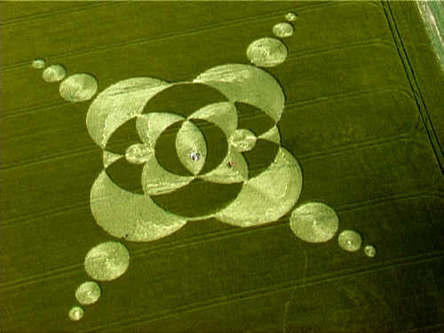
Photo by Stuart Dike, Crop Circle Archives (Crop Circle Connector)
- Date
- 4 June 2002
- Place
- Silbury Hill, near Avebury
- County or region
- Wiltshire
- Country
- England
- Crop
- Barley
- GPS
- 51.41171, -1.86372
- OS grid reference
- SU 0957 6808
- Nearest ancient site
- Silbury Hill, 0.6 km
- Reference codes
- LP-CCDB uk2002af
Photos23
Photos load from the archives that published them and remain the copyright of their photographers. Crop circle images and reports courtesy The Crop Circle Connector (cropcircleconnector.com). All sources and credits.
Reports
Crop Circle Archives (Crop Circle Connector)
Crop circle at Silbury Hill, nr Avebury, Wiltshire. reported 4th June. Silbury Hill, nr Avebury, Wiltshire. Reported 4th June. Map Ref: GPS SU09576808 Updated Wednesday, 16 September 2009 19:52:17 Video Images Stuart Dike Copyright 2002 DOWNLOAD REALMEDIA VIDEO 839K THE ELEVATED CROSS AT SILBURY…
Photos by Stuart Dike, Steve Alexander. Read the full report at Crop Circle Archives.
Crop Circle Archives (Crop Circle Connector)
Crop circle at Avebury Trusloe, nr Beckhampton, Wiltshire. Reported 2nd June. Avebury Trusloe, nr Beckhampton, Wiltshire. Reported 2nd June. Map Ref: GPS SU08786943 Updated Wednesday, 25 April 2012 13:48:10 Video Images Stuart Dike Copyright 2002 DOWNLOAD REALMEDIA VIDEO 703K A VISITOR FOR ADAM & EVE Image Steve…
Photos by Stuart Dike, Steve Alexander, Alexander, Michael Glickman. Read the full report at Crop Circle Archives.
Lucy Pringle Crop Circle Photography
A kind of celtic knot design with a 'looping' ring around it A kind of celtic knot design with a 'looping' ring around it
Photos by Lucy Pringle. Read the full report at Lucy Pringle.