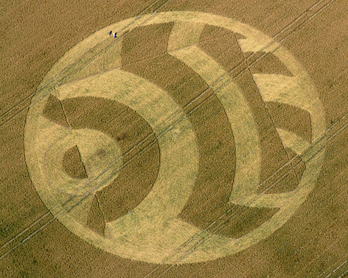
Photo by Nick Nicholson and the Crop Circle Connector, Crop Circle Archives (Crop Circle Connector)
- Date
- 14 July 2003
- Place
- Woodborough Hill, near Alton Barnes
- County or region
- Wiltshire
- Country
- England
- Crop
- Wheat
- GPS
- 51.34711, -1.83533
- OS grid reference
- SU 1156 6090
- Nearest ancient site
- Alton Barnes White Horse, 1.8 km
- Reference codes
- LP-CCDB uk2003bm
Photos15
Photos load from the archives that published them and remain the copyright of their photographers. Crop circle images and reports courtesy The Crop Circle Connector (cropcircleconnector.com). All sources and credits.
Reports
Crop Circle Archives (Crop Circle Connector)
Crop Circle at Woodborough Hill, nr Alton Barnes, Wiltshire. Reported 14th July 2003. Woodborough Hill, nr Alton Barnes, Wiltshire. Reported 14th July. Map Ref: SU11566090 Updated Wednesday 27th August 2003 Images Nick Nicholson and the Crop Circle Connector Copyright 2003 WOODBOROUGH HILL. This small hillside…
Photos by Nick Nicholson and the Crop Circle Connector, M.J.Fussell, Mike & Elaine Howard, Bertold Zugelder. Read the full report at Crop Circle Archives.
Lucy Pringle Crop Circle Photography
A rather odd shape, non symmetrically based around a circle with a square outline within it A distant view of the Woodborough Hill formation
Photos by Lucy Pringle. Read the full report at Lucy Pringle.