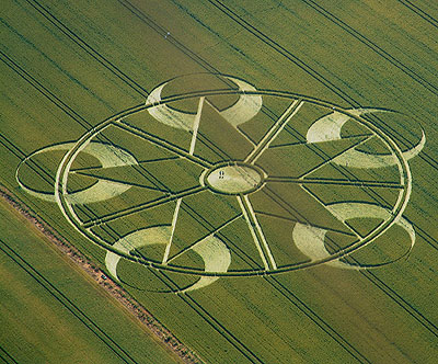
Photo by Nick Nicholson and the Crop Circle Connector, Crop Circle Archives (Crop Circle Connector)
- Date
- 13 July 2003
- Place
- Avebury Trusloe
- County or region
- Wiltshire
- Country
- England
- GPS
- 51.42720, -1.89129
- OS grid reference
- SU 0765 6980
- Nearest ancient site
- Windmill Hill, 2.2 km
- Reference codes
- LP-CCDB uk2003bk
Photos7
Photos load from the archives that published them and remain the copyright of their photographers. Crop circle images and reports courtesy The Crop Circle Connector (cropcircleconnector.com). All sources and credits.
Reports
Crop Circle Archives (Crop Circle Connector)
Crop Circle at Avebury Trusloe, Wiltshire. Reported 13th July 2003. Avebury Trusloe, nr Avebury, Wiltshire. Reported 13th July Map Ref: SU07656980 Updated Wednesday 20th August 2003 Images Nick Nicholson and the Crop Circle Connector Copyright 2003 AVEBURY TRUSLOE. A small hamlet just outside of the main village of…
Photos by Nick Nicholson and the Crop Circle Connector, Bertold Zugelder. Read the full report at Crop Circle Archives.
Lucy Pringle Crop Circle Photography
A ring containing a pentagonal star design. Disecting the ring and each point of the star is a crescent design A distant view showing more of the local view
Photos by Lucy Pringle. Read the full report at Lucy Pringle.