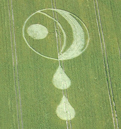
Photo by Steve Alexander, Crop Circle Archives (Crop Circle Connector)
- Date
- 15 July 2004
- Place
- South Field, near Alton Priors
- County or region
- Wiltshire
- Country
- England
- Crop
- Wheat
- GPS
- 51.35650, -1.83264
- OS grid reference
- SU 117 619
- Nearest ancient site
- Adam's Grave, 0.7 km
- Reference codes
- LP-CCDB uk2004bf
Photos20
Photos load from the archives that published them and remain the copyright of their photographers. Crop circle images and reports courtesy The Crop Circle Connector (cropcircleconnector.com). All sources and credits.
Reports
Crop Circle Archives (Crop Circle Connector)
Crop Circle at South Field, nr Alton Priors, Wiltshire. Reported 15th July 2004. South Field, nr Alton Priors, Wiltshire. Reported 15th July. Map Ref: SU117619 Updated Thursday 29th March 2012 Image Steve Alexander Copyright 2004 Images Nick Nicholson Copyright 2004 Click on thumbnails to enlarge Images Verity…
Photos by Steve Alexander, Nick Nicholson, Verity Bullock, Bertold Zugelder, Michael Murray. Read the full report at Crop Circle Archives.
Lucy Pringle Crop Circle Photography
A large ring containing flattened and standing crescents, with two flattened 'tear drop' shapes to the north side A large ring containing flattened and standing crescents, with two flattened 'tear drop' shapes to the north side
Photos by Lucy Pringle. Read the full report at Lucy Pringle.