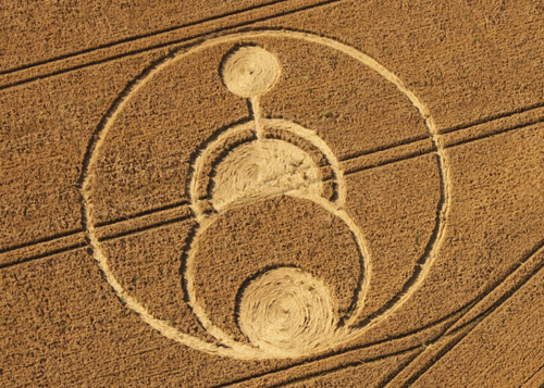
Photo by Wccsg, Crop Circle Archives (Crop Circle Connector)
- Date
- 27 July 2008
- Place
- Allington Down, near Devizes
- County or region
- Wiltshire
- Country
- England
- Crop
- Wheat
- GPS
- 51.37096, -1.89293
- OS grid reference
- SU 075 635
- Nearest ancient site
- Alton Barnes White Horse, 3.3 km
- Reference codes
- LP-CCDB uk2008bm
Photos45
Photos load from the archives that published them and remain the copyright of their photographers. Crop circle images and reports courtesy The Crop Circle Connector (cropcircleconnector.com). All sources and credits.
Reports
Crop Circle Archives (Crop Circle Connector)
Crop Circle at Allington Down, nr Devizes, Wiltshire. Reported 27th July 2008. Allington Down , nr Devizes, Wiltshire. Reported 27th July. Map Ref: SU075635 Updated Monday 4th August 2008 AERIAL SHOTS GROUND SHOTS DIAGRAMS FIELD REPORTS ARTICLES Image Gary King - WCCSG Copyright 2008 Image Peter Sorensen Copyright…
Photos by Wccsg, Peter Sorensen, Lucy Pringle, Tommy Borms, Bertold Zugelder. Read the full report at Crop Circle Archives.
Crop Circle Archives (Crop Circle Connector)
Crop Circle at Allington Down, nr Devizes, Wiltshire. Reported 27th July 2008. Honey Street (3), Nr Alton Barnes, Wiltshire. Reported 27th July. Map Ref: Updated Wednesday 19th September 2018 Images John Montgomery Copyright 2008 Image Francine Blake - WCCSG Copyright 2008 Please find attached picture that Francine…
Photos by John Montgomery, Wccsg, Stuart Dike, Lucy Pringle, Frank Laumen, Patty Greer, Bertold Zugelder, Janet Ossebaard, Tommy Borms, Daigrams Wener Vogl, Abby Willowroot. Read the full report at Crop Circle Archives.
Lucy Pringle Crop Circle Photography
A ring with inscribed circles and crescents within it
Photos by Lucy Pringle. Read the full report at Lucy Pringle.