Crop Circle Archives (Crop Circle Connector)
Milk Hill, Wiltshire 29 May 2005, barley, 32 photos
Date 29 May 2005
Place Milk Hill, near Stanton St Bernard
County or region Wiltshire
Country England
Crop Barley
GPS 51.36702, -1.86327
OS grid reference SU 0961 6311
Nearest ancient site Alton Barnes White Horse, 1.2 km
Reference codes LP-CCDB uk2005ai Photos32
Crop Circle Archives (Crop Circle Connector)
Crop Circle Archives (Crop Circle Connector)
Photo by Steve Alexander, Crop Circle Archives (Crop Circle Connector)
Photo by Michael Glickman, Crop Circle Archives (Crop Circle Connector)
Photo by Michael Glickman, Crop Circle Archives (Crop Circle Connector)
Crop Circle Archives (Crop Circle Connector)
Crop Circle Archives (Crop Circle Connector)
Crop Circle Archives (Crop Circle Connector)
Crop Circle Archives (Crop Circle Connector)
Crop Circle Archives (Crop Circle Connector)
Crop Circle Archives (Crop Circle Connector)
Crop Circle Archives (Crop Circle Connector)
Crop Circle Archives (Crop Circle Connector)
Crop Circle Archives (Crop Circle Connector)
Crop Circle Archives (Crop Circle Connector)
Photo by Alex (for x-cosmos), Crop Circle Archives (Crop Circle Connector)
Photo by Alex (for x-cosmos), Crop Circle Archives (Crop Circle Connector)
Photo by Michael Murray, Crop Circle Archives (Crop Circle Connector)
Photo by Michael Murray, Crop Circle Archives (Crop Circle Connector)
Photo by Michael Murray, Crop Circle Archives (Crop Circle Connector)
Photo by Michael Murray, Crop Circle Archives (Crop Circle Connector)
Photo by Michael Murray, Crop Circle Archives (Crop Circle Connector)
Photo by Michael Murray, Crop Circle Archives (Crop Circle Connector)
Photo by Michael Murray, Crop Circle Archives (Crop Circle Connector)
Photo by Michael Murray, Crop Circle Archives (Crop Circle Connector)
Photo by Michael Murray, Crop Circle Archives (Crop Circle Connector)
Photo by Michael Murray, Crop Circle Archives (Crop Circle Connector)
Photo by Michael Murray, Crop Circle Archives (Crop Circle Connector)
Crop Circle Archives (Crop Circle Connector)
Crop Circle Archives (Crop Circle Connector)
Temporary Temples
Photo by Lucy Pringle, Lucy Pringle Crop Circle Photography Photos load from the archives that published them and remain the copyright of their photographers. Crop circle images and reports courtesy The Crop Circle Connector (cropcircleconnector.com). All sources and credits .
Reports
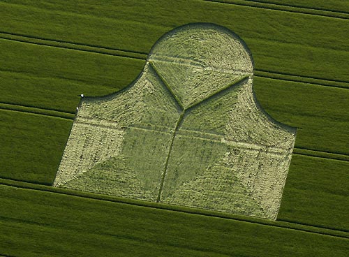
Crop Circle at Milk Hill, Nr Stanton St Bernard, Wiltshire. Reported 29th May 2005 Milk Hill, Nr Stanton St Bernard, Wiltshire. Reported 29th May. Map Ref: SU0 9616311 Updated Wednesday 28th June 2005 Images CCC Copyright 2005 Image Steve Alexander Copyright 2005 MILK HILL REPORT. Probably the most unusual and…
A rather irregular shape consisting of two squares and a circle, with additional flattened curved joins