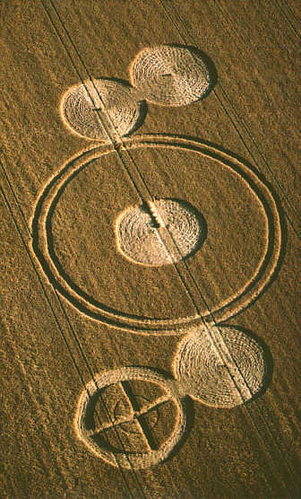
Photo by Alexander, Crop Circle Archives (Crop Circle Connector)
Windmill Hill, Wiltshire 7 August 2000, wheat, 18 photos
Date 7 August 2000
Place Windmill Hill, near Avebury
County or region Wiltshire
Country England
Crop Wheat
Reference codes LP-CCDB uk2000dq Photos18
Photo by Alexander, Crop Circle Archives (Crop Circle Connector)
Photo by Peter Sorensen, Crop Circle Archives (Crop Circle Connector)
Photo by Peter Sorensen, Crop Circle Archives (Crop Circle Connector)
Photo by Stuart Dike, Crop Circle Archives (Crop Circle Connector)
Photo by Stuart Dike, Crop Circle Archives (Crop Circle Connector)
Photo by Stuart Dike, Crop Circle Archives (Crop Circle Connector)
Photo by Stuart Dike, Crop Circle Archives (Crop Circle Connector)
Photo by Stuart Dike, Crop Circle Archives (Crop Circle Connector)
Photo by Stuart Dike, Crop Circle Archives (Crop Circle Connector)
Photo by Stuart Dike, Crop Circle Archives (Crop Circle Connector)
Photo by Stuart Dike, Crop Circle Archives (Crop Circle Connector)
Photo by Stuart Dike, Crop Circle Archives (Crop Circle Connector)
Photo by Stuart Dike, Crop Circle Archives (Crop Circle Connector)
Photo by Stuart Dike, Crop Circle Archives (Crop Circle Connector)
Photo by Stuart Dike, Crop Circle Archives (Crop Circle Connector)
Photo by Stuart Dike, Crop Circle Archives (Crop Circle Connector)
Temporary Temples
Photo by Lucy Pringle, Lucy Pringle Crop Circle Photography Photos load from the archives that published them and remain the copyright of their photographers. Crop circle images and reports courtesy The Crop Circle Connector (cropcircleconnector.com). All sources and credits .
Reports
Windmill Hill, nr Avebury, Wiltshire. Reported 7th August. ContentZone Windmill Hill (2), nr Avebury, Wiltshire. Reported 7th August. GPS Reference Updated Friday 29th September 2000 Image Steve Alexander Copyright 2000 Click on thumbnail for full image Video image by Peter Sorensen. Copyright 2000 Click here to…
A circle joined to a small circle disected by two paths and a very thin ring. A larger central circle and a figure of eight pattern made this a very pleasing formation
Same field, other years Windmill Hill, Wiltshire 29 July 1996 Windmill Hill, Wiltshire 18 June 2000 Windmill Hill (3), Wiltshire 12 August 2000 Windmill Hill (4), Wiltshire 19 August 2000 Windmill Hill (5), Wiltshire 19 August 2000 Windmill Hill, Wiltshire 18 July 2002 Windmill Hill (2), Wiltshire 2 August 2002 Windmill Hill, Wiltshire 6 June 2003 Windmill Hill (2), Wiltshire 19 June 2003 Windmill Hill, Wiltshire 22 June 2003 Windmill Hill, Wiltshire 17 July 2004 Windmill Hill (2), Wiltshire 21 July 2004 Windmill Hill, Wiltshire 23 June 2005 Windmill Hill, Wiltshire 20 June 2006 Windmill Hill, Wiltshire 30 June 2006 Windmill Hill, Wiltshire 25 May 2009 Windmill Hill, Wiltshire 6 August 2009 Windmill Hill, Wiltshire 27 July 2010 Windmill Hill, Wiltshire 13 July 2011 Windmill Hill, Wiltshire 26 July 2011 The same week Stonor House, Oxon/Bucks 4 August 2000 Vuren, Netherlands 4 August 2000 Broadbury Banks (1), Wiltshire 5 August 2000 Broadbury Banks (2), Wiltshire 5 August 2000 Whiskey Hill Road, USA 5 August 2000 Broadbury Banks, Wiltshire 6 August 2000 Brummen, Netherlands 6 August 2000 Cherhill Field, Wiltshire 6 August 2000 Farm World, Wales 6 August 2000 Neudorf, Germany 6 August 2000 The Knoll, Wiltshire 6 August 2000 All Cannings Bridge, Wiltshire 7 August 2000