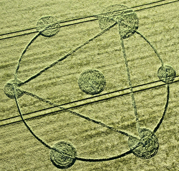
Photo by John Montgomery, Crop Circle Archives (Crop Circle Connector)
Burderop Down, Wiltshire 22 May 2011, barley, 38 photos
Date 22 May 2011
Place Burderop Down, near Nr Wroughton
County or region Wiltshire
Country England
Crop Barley
GPS 51.49216, -1.76301
OS grid reference SU 165 770
Nearest ancient site Barbury Castle, 1.8 km Photos38
Photo by John Montgomery, Crop Circle Archives (Crop Circle Connector)
Photo by John Montgomery, Crop Circle Archives (Crop Circle Connector)
Photo by John Montgomery, Crop Circle Archives (Crop Circle Connector)
Photo by Lucy Pringle, Crop Circle Archives (Crop Circle Connector)
Photo by Steve Alexander, Crop Circle Archives (Crop Circle Connector)
Photo by Steve Alexander, Crop Circle Archives (Crop Circle Connector)
Photo by Steve Alexander, Crop Circle Archives (Crop Circle Connector)
Photo by Steve Alexander, Crop Circle Archives (Crop Circle Connector)
Photo by John Montgomery, Crop Circle Archives (Crop Circle Connector)
Photo by Fred Rusher, Crop Circle Archives (Crop Circle Connector)
Photo by Fred Rusher, Crop Circle Archives (Crop Circle Connector)
Photo by Fred Rusher, Crop Circle Archives (Crop Circle Connector)
Photo by Fred Rusher, Crop Circle Archives (Crop Circle Connector)
Photo by Lucy Pringle, Crop Circle Archives (Crop Circle Connector)
Photo by Newton Rampasso, Crop Circle Archives (Crop Circle Connector)
Photo by Lucy Pringle, Crop Circle Archives (Crop Circle Connector)
Photo by Bertold Zugelder, Crop Circle Archives (Crop Circle Connector)
Photo by Rabbit, Crop Circle Archives (Crop Circle Connector)
Photo by Rabbit, Crop Circle Archives (Crop Circle Connector)
Photo by Stuart Dike (The Crop Circle Connector), Crop Circle Archives (Crop Circle Connector)
Photo by Stuart Dike (The Crop Circle Connector), Crop Circle Archives (Crop Circle Connector)
Photo by Stuart Dike (The Crop Circle Connector), Crop Circle Archives (Crop Circle Connector)
Photo by Stuart Dike (The Crop Circle Connector), Crop Circle Archives (Crop Circle Connector)
Photo by Stuart Dike (The Crop Circle Connector), Crop Circle Archives (Crop Circle Connector)
Photo by Stuart Dike (The Crop Circle Connector), Crop Circle Archives (Crop Circle Connector)
Photo by Stuart Dike (The Crop Circle Connector), Crop Circle Archives (Crop Circle Connector)
Photo by Stuart Dike (The Crop Circle Connector), Crop Circle Archives (Crop Circle Connector)
Photo by Stuart Dike (The Crop Circle Connector), Crop Circle Archives (Crop Circle Connector)
Photo by Stuart Dike (The Crop Circle Connector), Crop Circle Archives (Crop Circle Connector)
Photo by Stuart Dike (The Crop Circle Connector), Crop Circle Archives (Crop Circle Connector)
Photo by Stuart Dike (The Crop Circle Connector), Crop Circle Archives (Crop Circle Connector)
Photo by Stuart Dike (The Crop Circle Connector), Crop Circle Archives (Crop Circle Connector)
Photo by Lucy Pringle, Crop Circle Archives (Crop Circle Connector)
Temporary Temples
Temporary Temples
Temporary Temples
Temporary Temples
Temporary Temples Photos load from the archives that published them and remain the copyright of their photographers. Crop circle images and reports courtesy The Crop Circle Connector (cropcircleconnector.com). All sources and credits .
Reports
Crop Circle at Burderop Down, nr Nr Wroughton, Wiltshire. Reported 22nd May 2011. Burderop Down, nr Nr Wroughton, Wiltshire. Reported 22nd May. Map Ref: SU165770 This Page has been accessed Updated Wednesday 1st June 2011 AERIAL SHOTS GROUND SHOTS DIAGRAMS FIELD REPORTS COMMENTS ARTICLES 24/05/11 25/05/11 25/05/11…