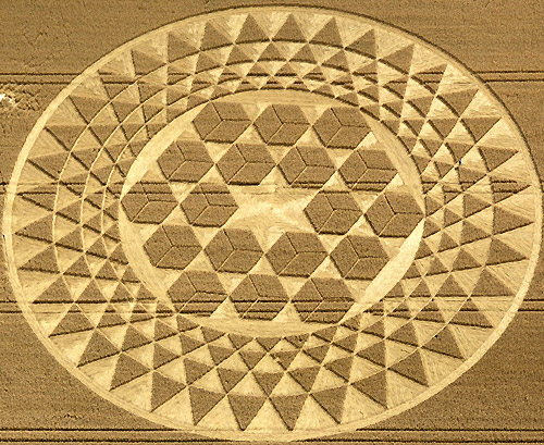
Photo by John Montgomery, Crop Circle Archives (Crop Circle Connector)
Sugar Hill, Wiltshire 1 August 2007, wheat, 58 photos
Date 1 August 2007
Place Sugar Hill, near Upper Upham
County or region Wiltshire
Country England
Crop Wheat
Reference codes LP-CCDB uk2007br Photos58
Photo by John Montgomery, Crop Circle Archives (Crop Circle Connector)
Photo by John Montgomery, Crop Circle Archives (Crop Circle Connector)
Photo by John Montgomery, Crop Circle Archives (Crop Circle Connector)
Photo by John Montgomery, Crop Circle Archives (Crop Circle Connector)
Photo by John Montgomery, Crop Circle Archives (Crop Circle Connector)
Photo by John Montgomery, Crop Circle Archives (Crop Circle Connector)
Photo by Steve Alexander, Crop Circle Archives (Crop Circle Connector)
Photo by Steve Alexander, Crop Circle Archives (Crop Circle Connector)
Photo by Steve Alexander, Crop Circle Archives (Crop Circle Connector)
Photo by Steve Alexander, Crop Circle Archives (Crop Circle Connector)
Photo by Steve Alexander, Crop Circle Archives (Crop Circle Connector)
Photo by Steve Alexander, Crop Circle Archives (Crop Circle Connector)
Photo by Steve Alexander, Crop Circle Archives (Crop Circle Connector)
Photo by Lucy Pringle, Crop Circle Archives (Crop Circle Connector)
Crop Circle Archives (Crop Circle Connector)
Photo by Bertold Zugelder, Crop Circle Archives (Crop Circle Connector)
Crop Circle Archives (Crop Circle Connector)
Crop Circle Archives (Crop Circle Connector)
Photo by Frank Laumen, Crop Circle Archives (Crop Circle Connector)
Photo by Frank Laumen, Crop Circle Archives (Crop Circle Connector)
Photo by Frank Laumen, Crop Circle Archives (Crop Circle Connector)
Photo by Frank Laumen, Crop Circle Archives (Crop Circle Connector)
Photo by Frank Laumen, Crop Circle Archives (Crop Circle Connector)
Photo by Frank Laumen, Crop Circle Archives (Crop Circle Connector)
Photo by Frank Laumen, Crop Circle Archives (Crop Circle Connector)
Photo by Frank Laumen, Crop Circle Archives (Crop Circle Connector)
Photo by Frank Laumen, Crop Circle Archives (Crop Circle Connector)
Crop Circle Archives (Crop Circle Connector)
Photo by Steve Alexander, Crop Circle Archives (Crop Circle Connector)
Crop Circle Archives (Crop Circle Connector)
Photo by Bert Janssen, Crop Circle Archives (Crop Circle Connector)
Photo by Bert Janssen, Crop Circle Archives (Crop Circle Connector)
Photo by Bert Janssen, Crop Circle Archives (Crop Circle Connector)
Photo by Bert Janssen, Crop Circle Archives (Crop Circle Connector)
Photo by Bert Janssen, Crop Circle Archives (Crop Circle Connector)
Crop Circle Archives (Crop Circle Connector)
Crop Circle Archives (Crop Circle Connector)
Crop Circle Archives (Crop Circle Connector)
Crop Circle Archives (Crop Circle Connector)
Photo by Tommy Borms, Crop Circle Archives (Crop Circle Connector) , diagram
Crop Circle Archives (Crop Circle Connector)
Crop Circle Archives (Crop Circle Connector)
Crop Circle Archives (Crop Circle Connector)
Crop Circle Archives (Crop Circle Connector)
Crop Circle Archives (Crop Circle Connector)
Crop Circle Archives (Crop Circle Connector)
Crop Circle Archives (Crop Circle Connector)
Crop Circle Archives (Crop Circle Connector)
Temporary Temples
Temporary Temples
Temporary Temples
Temporary Temples
Temporary Temples
Temporary Temples
Temporary Temples
Temporary Temples
Temporary Temples
Photo by Lucy Pringle, Lucy Pringle Crop Circle Photography Photos load from the archives that published them and remain the copyright of their photographers. Crop circle images and reports courtesy The Crop Circle Connector (cropcircleconnector.com). All sources and credits .
Reports
Crop Circle at Sugar Hill, nr Upper Upham, Wiltshire. Reported 1st August 2007. Sugar Hill, nr Upper Upham, Wiltshire. Reported 1st August. Map Ref: This Page has been accessed Updated Thursday 23rd August 2007 AERIAL SHOTS GROUND SHOTS DIAGRAMS FIELD REPORTS ARTICLES The 18 cube circle appeared on Aug 1, or 8/1…
An elaborate design comprising 18 hexagonal squares of standing crop, resembling 3D 'Necker cubes'. Surrounding a flattened circle containing the squares are four concentric rings of 36 standing triangles in each ring, totalling 144 triangles in total
Same field, other years
The same week