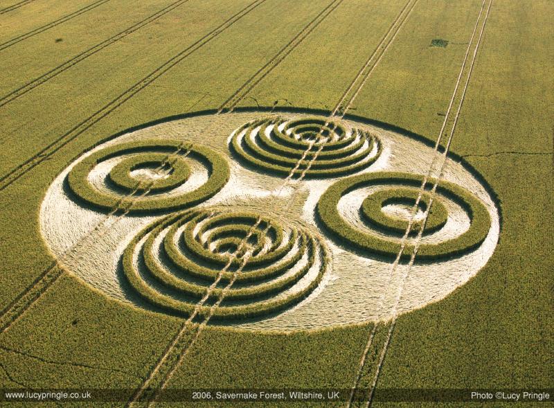
Photo by Lucy Pringle, Crop Circle Archives (Crop Circle Connector)
Savernake Forest, Wiltshire 8 July 2006, wheat, 53 photos
Date 8 July 2006
Place Savernake Forest, near Marlborough
County or region Wiltshire
Country England
Crop Wheat
GPS 51.41642, -1.67569
OS grid reference SU 226 686
Nearest ancient site Martinsell Hill, 5.6 km
Reference codes LP-CCDB uk2006au Photos53
Photo by Lucy Pringle, Crop Circle Archives (Crop Circle Connector)
Photo by Lucy Pringle, Crop Circle Archives (Crop Circle Connector)
Crop Circle Archives (Crop Circle Connector)
Crop Circle Archives (Crop Circle Connector)
Photo by Bertold Zugelder, Crop Circle Archives (Crop Circle Connector)
Photo by Bertold Zugelder, Crop Circle Archives (Crop Circle Connector)
Photo by Bertold Zugelder, Crop Circle Archives (Crop Circle Connector)
Photo by Bertold Zugelder, Crop Circle Archives (Crop Circle Connector)
Photo by Bertold Zugelder, Crop Circle Archives (Crop Circle Connector)
Photo by Bertold Zugelder, Crop Circle Archives (Crop Circle Connector)
Photo by Bertold Zugelder, Crop Circle Archives (Crop Circle Connector)
Photo by Bertold Zugelder, Crop Circle Archives (Crop Circle Connector)
Photo by Bertold Zugelder, Crop Circle Archives (Crop Circle Connector)
Photo by Bertold Zugelder, Crop Circle Archives (Crop Circle Connector)
Photo by Bertold Zugelder, Crop Circle Archives (Crop Circle Connector)
Photo by Bertold Zugelder, Crop Circle Archives (Crop Circle Connector)
Photo by Bertold Zugelder, Crop Circle Archives (Crop Circle Connector)
Photo by Bertold Zugelder, Crop Circle Archives (Crop Circle Connector)
Photo by Bertold Zugelder, Crop Circle Archives (Crop Circle Connector)
Photo by Bertold Zugelder, Crop Circle Archives (Crop Circle Connector)
Crop Circle Archives (Crop Circle Connector)
Photo by Mike Murray, Crop Circle Archives (Crop Circle Connector) , diagram
Photo by Mike Murray, Crop Circle Archives (Crop Circle Connector)
Photo by Lucy Pringle, Crop Circle Archives (Crop Circle Connector)
Photo by Nick Nicholson, Crop Circle Archives (Crop Circle Connector)
Photo by Mike Murray, Crop Circle Archives (Crop Circle Connector)
Photo by Mike Murray, Crop Circle Archives (Crop Circle Connector)
Photo by Mike Murray, Crop Circle Archives (Crop Circle Connector)
Photo by Mike Murray, Crop Circle Archives (Crop Circle Connector)
Photo by Mike Murray, Crop Circle Archives (Crop Circle Connector)
Photo by Mike Murray, Crop Circle Archives (Crop Circle Connector)
Photo by Mike Murray, Crop Circle Archives (Crop Circle Connector)
Photo by Mike Murray, Crop Circle Archives (Crop Circle Connector)
Photo by Mike Murray, Crop Circle Archives (Crop Circle Connector)
Photo by Mike Murray, Crop Circle Archives (Crop Circle Connector)
Photo by Mike Murray, Crop Circle Archives (Crop Circle Connector)
Photo by Mike Murray, Crop Circle Archives (Crop Circle Connector)
Photo by Mike Murray, Crop Circle Archives (Crop Circle Connector)
Photo by Mike Murray, Crop Circle Archives (Crop Circle Connector)
Photo by Mike Murray, Crop Circle Archives (Crop Circle Connector)
Photo by Mike Murray, Crop Circle Archives (Crop Circle Connector)
Photo by Mike Murray, Crop Circle Archives (Crop Circle Connector)
Photo by Mike Murray, Crop Circle Archives (Crop Circle Connector)
Photo by Mike Murray, Crop Circle Archives (Crop Circle Connector)
Photo by Mike Murray, Crop Circle Archives (Crop Circle Connector)
Temporary Temples
Temporary Temples
Temporary Temples
Temporary Temples
Photo by Lucy Pringle, Lucy Pringle Crop Circle Photography
Photo by Lucy Pringle, Lucy Pringle Crop Circle Photography
Photo by Lucy Pringle, Lucy Pringle Crop Circle Photography
Photo by Lucy Pringle, Lucy Pringle Crop Circle Photography Photos load from the archives that published them and remain the copyright of their photographers. Crop circle images and reports courtesy The Crop Circle Connector (cropcircleconnector.com). All sources and credits .
Reports
Crop Circle at Savernake Forest, nr Marlborough, Wiltshire. Reported 8th July 2006. Savernake Forest , nr Marlborough, Wiltshire. Reported 8th July. Map Ref: SU226686 This Page has been accessed Tuesday 28th August 2018 AERIAL SHOTS GROUND SHOTS DIAGRAMS FIELD REPORTS Images Lucy Pringle Copyright 2018 Large…
Large formation containing two opposing concentric ring patterns and two opposing 3D nested crescent designs Large formation containing two opposing concentric ring patterns and two opposing 3D nested crescent designs. The end of another season