Crop Circle Archives (Crop Circle Connector)
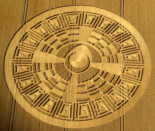
Wayland's Smithy, Oxfordshire 9 August 2005, wheat, 41 photos
Date 9 August 2005
Place Wayland's Smithy, near Ashbury
County or region Oxfordshire
Country England
Crop Wheat
GPS 51.56823, -1.59009
OS grid reference SU 28508 85564
Nearest ancient site Wayland's Smithy, 0.5 km
Reference codes LP-CCDB uk2005cl Photos41
Crop Circle Archives (Crop Circle Connector)
Crop Circle Archives (Crop Circle Connector)
Crop Circle Archives (Crop Circle Connector)
Photo by Steve Alexander, Crop Circle Archives (Crop Circle Connector)
Photo by Steve Alexander, Crop Circle Archives (Crop Circle Connector)
Photo by Bertold Zugelder, Crop Circle Archives (Crop Circle Connector)
Photo by Bertold Zugelder, Crop Circle Archives (Crop Circle Connector)
Photo by Jaime Maussan, Crop Circle Archives (Crop Circle Connector)
Crop Circle Archives (Crop Circle Connector)
Crop Circle Archives (Crop Circle Connector)
Crop Circle Archives (Crop Circle Connector)
Crop Circle Archives (Crop Circle Connector)
Crop Circle Archives (Crop Circle Connector)
Crop Circle Archives (Crop Circle Connector)
Crop Circle Archives (Crop Circle Connector)
Photo by Bertold Zugelder, Crop Circle Archives (Crop Circle Connector)
Photo by Photographs Mike Callahan, Crop Circle Archives (Crop Circle Connector)
Photo by Photographs Mike Callahan, Crop Circle Archives (Crop Circle Connector)
Photo by Photographs Mike Callahan, Crop Circle Archives (Crop Circle Connector)
Photo by Photographs Mike Callahan, Crop Circle Archives (Crop Circle Connector)
Photo by Photographs Mike Callahan, Crop Circle Archives (Crop Circle Connector)
Photo by Photographs Mike Callahan, Crop Circle Archives (Crop Circle Connector)
Photo by Photographs Mike Callahan, Crop Circle Archives (Crop Circle Connector)
Photo by Photographs Mike Callahan, Crop Circle Archives (Crop Circle Connector)
Photo by Photographs Mike Callahan, Crop Circle Archives (Crop Circle Connector)
Photo by Photographs Mike Callahan, Crop Circle Archives (Crop Circle Connector)
Photo by Photographs Mike Callahan, Crop Circle Archives (Crop Circle Connector)
Photo by Photographs Mike Callahan, Crop Circle Archives (Crop Circle Connector)
Crop Circle Archives (Crop Circle Connector)
Crop Circle Archives (Crop Circle Connector)
Photo by Lucy Pringle, Crop Circle Archives (Crop Circle Connector)
Photo by Lucy Pringle, Crop Circle Archives (Crop Circle Connector)
Photo by Lucy Pringle, Crop Circle Archives (Crop Circle Connector)
Photo by Annemieke Witteveen, Crop Circle Archives (Crop Circle Connector)
Temporary Temples
Temporary Temples
Temporary Temples
Temporary Temples
Photo by Lucy Pringle, Lucy Pringle Crop Circle Photography
Photo by Lucy Pringle, Lucy Pringle Crop Circle Photography
Photo by Lucy Pringle, Lucy Pringle Crop Circle Photography Photos load from the archives that published them and remain the copyright of their photographers. Crop circle images and reports courtesy The Crop Circle Connector (cropcircleconnector.com). All sources and credits .
Reports
Crop Circle at Wayland's Smithy, nr Ashbury, Oxfordshire. Reported 9th August 2005 Wayland's Smithy, nr Ashbury, Oxfordshire. Reported 9th August. Map Ref: SU2850885564 Updated Thursday 1st September 2005 Huhnab Ku, the God the Center of the Universe The Aztec-Mayan Calendar Meets Modern Computers by C . Lewis…
A rather simplified copy of 2004's 'Mayan Calendar' formation A rather simplified copy of 2004's 'Mayan Calendar' formation