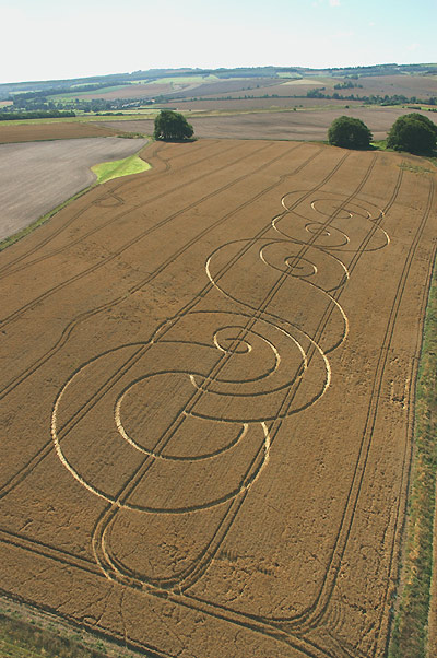
Photo by Steve Alexander, Crop Circle Archives (Crop Circle Connector)
- Date
- 29 July 2005
- Place
- Avebury Stone Avenue, near Avebury
- County or region
- Wiltshire
- Country
- England
- Crop
- Wheat
- GPS
- 51.42124, -1.83241
- OS grid reference
- SU 117 691
- Nearest ancient site
- The Sanctuary, 1.1 km
- Reference codes
- LP-CCDB uk2005cf
Photos25
Photos load from the archives that published them and remain the copyright of their photographers. Crop circle images and reports courtesy The Crop Circle Connector (cropcircleconnector.com). All sources and credits.
Reports
Crop Circle Archives (Crop Circle Connector)
Crop Circle at Avebury Stone Avenue, nr Avebury, Wiltshire. Reported 29th July 2005 Avebury Stone Avenue, nr Avebury, Wiltshire. Reported 29th July. Map Ref: Updated Thursday 4th August 2005 Image Steve Alexander Copyright 2005 Image Axel Kayser Copyright 2005 Images Francine Blake Copyright 2005 Stretched Image…
Photos by Steve Alexander, Axel Kayser, Francine Blake, Andreas Muller, Lucy Pringle. Read the full report at Crop Circle Archives.
Crop Circle Archives (Crop Circle Connector)
Crop Circle at The Ridgeway, nr Avebury, Wiltshire. Reported 31st July 2005 The Ridgeway, nr Avebury, Wiltshire. Reported 31st July. Map Ref: Approx SU117691 Updated Friday 5th August 2005 Images CCC Copyright 2005 The Anonymous Pathway The field next to the Ridgeway with the multiple ringed circle has a…
Photos by Steve Alexander, Terje Toftenes, Lucy Pringle. Read the full report at Crop Circle Archives (2 pages).
Lucy Pringle Crop Circle Photography
A long design based on several interlocking semi-circular designs
Photos by Lucy Pringle. Read the full report at Lucy Pringle.