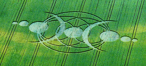
Photo by Andrew King, Crop Circle Archives (Crop Circle Connector)
Cuxham, Oxfordshire 28 June 2005, wheat, 27 photos
Date 28 June 2005
Place Cuxham, near Watlington
County or region Oxfordshire
Country England
Crop Wheat
GPS 51.66390, -1.05222
OS grid reference SU 656 965
Nearest ancient site Uffington White Horse, 36.8 km
Reference codes LP-CCDB uk2005bb Photos27
Photo by Andrew King, Crop Circle Archives (Crop Circle Connector)
Photo by Andrew King, Crop Circle Archives (Crop Circle Connector)
Photo by Ellis Taylor, Crop Circle Archives (Crop Circle Connector)
Photo by Ellis Taylor, Crop Circle Archives (Crop Circle Connector)
Photo by Ellis Taylor, Crop Circle Archives (Crop Circle Connector)
Photo by Ellis Taylor, Crop Circle Archives (Crop Circle Connector)
Photo by Ellis Taylor, Crop Circle Archives (Crop Circle Connector)
Photo by Ellis Taylor, Crop Circle Archives (Crop Circle Connector)
Photo by Ellis Taylor, Crop Circle Archives (Crop Circle Connector)
Photo by Ellis Taylor, Crop Circle Archives (Crop Circle Connector)
Photo by Ellis Taylor, Crop Circle Archives (Crop Circle Connector)
Photo by Ellis Taylor, Crop Circle Archives (Crop Circle Connector)
Photo by Ellis Taylor, Crop Circle Archives (Crop Circle Connector)
Photo by Ellis Taylor, Crop Circle Archives (Crop Circle Connector)
Photo by Ellis Taylor, Crop Circle Archives (Crop Circle Connector)
Photo by Ellis Taylor, Crop Circle Archives (Crop Circle Connector)
Photo by Ellis Taylor, Crop Circle Archives (Crop Circle Connector)
Photo by Ellis Taylor, Crop Circle Archives (Crop Circle Connector)
Photo by Ellis Taylor, Crop Circle Archives (Crop Circle Connector)
Photo by Ellis Taylor, Crop Circle Archives (Crop Circle Connector)
Photo by Ellis Taylor, Crop Circle Archives (Crop Circle Connector)
Photo by David Schwartzman, Crop Circle Archives (Crop Circle Connector)
Photo by David Schwartzman, Crop Circle Archives (Crop Circle Connector)
Photo by David Schwartzman, Crop Circle Archives (Crop Circle Connector)
Photo by David Schwartzman, Crop Circle Archives (Crop Circle Connector)
Photo by David Schwartzman, Crop Circle Archives (Crop Circle Connector)
Photo by Lucy Pringle, Lucy Pringle Crop Circle Photography Photos load from the archives that published them and remain the copyright of their photographers. Crop circle images and reports courtesy The Crop Circle Connector (cropcircleconnector.com). All sources and credits .
Reports
Crop Circle at Cuxham, nr Watlington ,Oxfordshire, Reported 28th June 2005 Cuxham , nr Watlington ,Oxfordshire, Reported 28th June. Map Ref: SU656965 Updated Wednesday 7th July 2005 The Wiltshire Microlight Centre First aerial shots of the CIRCULAR Crop Circle at Cuxham from Andrew King. Images Andrew King…
An elaborate design of curves and paths. More info soon