Skip to content
CROP DECODER
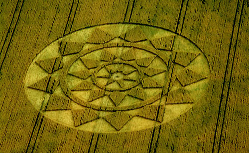
Etchilhampton Hill, Wiltshire crop circle from the air
Photo by Nick Nicholson, Crop Circle Archives (Crop Circle Connector)

Etchilhampton Hill, Wiltshire

25 July 2004, wheat, 25 photos
See all 25 photos
Date
25 July 2004
Place
Etchilhampton Hill, near Devizes
County or region
Wiltshire
Country
England
Crop
Wheat
GPS
51.34313, -1.95760
OS grid reference
SU 030 604
Nearest ancient site
Alton Barnes White Horse, 7.8 km
Reference codes
LP-CCDB uk2004bp

Photos25

Photos load from the archives that published them and remain the copyright of their photographers. Crop circle images and reports courtesy The Crop Circle Connector (cropcircleconnector.com). All sources and credits.

Reports

Crop Circle Archives (Crop Circle Connector)

Crop Circle at Etchilhampton Hill, nr Devizes, Wiltshire. Reported 25th July 2004. Etchilhampton Hill, nr Devizes, Wiltshire. Reported 25th July. Map Ref: SU030604 Updated Wednesday 11th August 2004 Image Nick Nicholson Copyright 2004 Discuss this Crop Circle on the Forum Image Steve Alexander Copyright 2004…
Photos by Nick Nicholson, Steve Alexander, Julian Gibsone, Eva Brekkestø, Michael Murray, Bertold Zugelder. Read the full report at Crop Circle Archives.

Lucy Pringle Crop Circle Photography

This is a star design with triangular shapes inside it and complex bundles and spiral twists at the centre This is a star design with triangular shapes inside it and complex bundles and spiral twists at the centre
Photos by Lucy Pringle. Read the full report at Lucy Pringle.