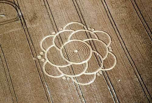
Photo by Andrew King, Crop Circle Archives (Crop Circle Connector)
- Date
- 26 June 2003
- Place
- Ulley, near Aughton, South
- County or region
- Yorkshire
- Country
- England
- GPS
- 51.13898, -1.85809
- OS grid reference
- SU 1002 3775
- Nearest ancient site
- Stonehenge, 5.0 km
Photos8
Photos load from the archives that published them and remain the copyright of their photographers. Crop circle images and reports courtesy The Crop Circle Connector (cropcircleconnector.com). All sources and credits.
Reports
Crop Circle Archives (Crop Circle Connector)
Crop Circle at Ulley, nr Aughton, South Yorkshire. Reported 26th June 2003. Camp Field (1), Middle Woodford, Wiltshire. Reported 15th July. Map Ref: SU10023775 (Approx) Updated Wednesday 23rd July 2003 Images Andrew King Copyright 2003 Images M.J.Fussell Copyright 2003 THE FARMER GUY RASCH HAS ASKED THAT NO ONE…
Photos by Andrew King, M.J.Fussell, Bertold Zugelder. Read the full report at Crop Circle Archives.
Crop Circle Archives (Crop Circle Connector)
Crop Circle at Ulley, nr Aughton, South Yorkshire. Reported 26th June 2003. Ulley, nr Aughton, South Yorkshire. Reported 26th June. Map Ref: Updated Thursday 26th June 2003 Images Anthony Wheeler Copyright 2003 The formation is about 120ft Return to June 2003 Mark Fussell & Stuart Dike
Photos by Anthony Wheeler. Read the full report at Crop Circle Archives.