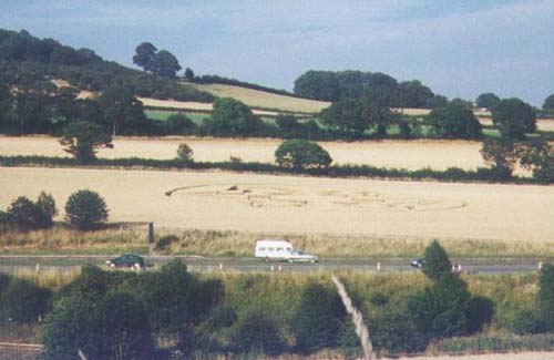
Photo by The Northern Circular, Crop Circle Archives (Crop Circle Connector)
- Date
- 27 July 2002
- Place
- Gilroyd, near Dodworth, South
- County or region
- Yorkshire
- Country
- England
- Crop
- Wheat
- GPS
- 53.53747, -1.50431
- OS grid reference
- SE 329 046
- Nearest ancient site
- Rollright Stones, 173.7 km
- Reference codes
- CCRA ENYS200203
Photos6
Photos load from the archives that published them and remain the copyright of their photographers. Crop circle images and reports courtesy The Crop Circle Connector (cropcircleconnector.com). All sources and credits.
Reports
Crop Circle Archives (Crop Circle Connector)
Crop circle at Gilroyd, nr Dodworth, South Yorkshire. Reported 27th July 2002 Gilroyd, nr Dodworth, South Yorkshire. Reported 27th July. Map Ref: GPS APPROX Updated Wednesday 6th August 2002 Image The Northern Circular Copyright 2002 The outer ring is approx 180 - 200 ft across and is divided into six equal…
Photos by The Northern Circular. Read the full report at Crop Circle Archives.
Crop Circle Archives (Crop Circle Connector)
Crop circle at Gilroyd, nr Dodworth, South Yorkshire. Reported 27th July 2002 Gilroyd (2), nr Dodworth, South Yorkshire. Reported 5th August. Map Ref: GPS APPROX Updated Wednesday 6th August 2002 Image Paul Chambers Copyright 2002 I REPORTED A CROP CIRCLE EARLIER TODAY AT GILROYD NEAR BARNSLEY. I STATED IT WAS M1…
Photos by Paul Chambers. Read the full report at Crop Circle Archives.