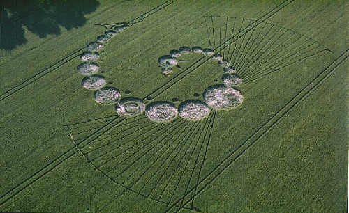
Photo by Steve Alexander, Crop Circle Archives (Crop Circle Connector)
- Date
- 23 June 2002
- Place
- Uffington White Horse, near Woolstone
- County or region
- Oxfordshire
- Country
- England
- Crop
- Wheat
- GPS
- 51.58444, -1.56761
- OS grid reference
- SU 3005 8737
- Nearest ancient site
- Uffington White Horse, 0.8 km
- Reference codes
- LP-CCDB uk2002aq
Photos6
Photos load from the archives that published them and remain the copyright of their photographers. Crop circle images and reports courtesy The Crop Circle Connector (cropcircleconnector.com). All sources and credits.
Reports
Crop Circle Archives (Crop Circle Connector)
Crop circle at Uffington White Horse, nr Woolstone, Oxfordshire. Reported 23rd June 2002 CLICK HERE Uffington White Horse, nr Woolstone, Oxfordshire. Reported 23rd June. Map Ref: GPS SU30058737 Updated Tuesday 25th June Take an air experience over the crop circles Images Steve Alexander Copyright 2002 The farmer…
Photos by Steve Alexander. Read the full report at Crop Circle Archives.
Lucy Pringle Crop Circle Photography
A spiral comprised of varying sized circles. A number of faint construction lines also 'fan out' to a circular perimeter A spiral comprised of varying sized circles. A number of faint construction lines also 'fan out' to a circular perimeter
Photos by Lucy Pringle. Read the full report at Lucy Pringle.